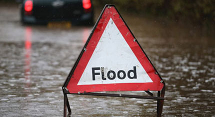
19.30pm, Saturday 16 November
A flood warning has been put in place for Butts Drain in the Butts Road and Marsh Lane areas of Barton-on-Humber.
The Environment Agency has said immediate action required.
The warning reads: “This flood warning is being issued in response to groundwater flooding in Barton upon Humber. Exceptional rainfall over the last couple of months has resulted in increasing groundwater levels.
“It is expected that rising groundwater levels will lead to property flooding in the Barton upon Humber. Properties at greatest risk are situated on Lower Meadows, Nursery Close, Butts Road, Marsh Lane and Fenland Court. Properties on higher ground around Pasture Road, Falkland Way, Harrier Road, Greenway, Whiston Way, St Peters Orchard, Queen’s Avenue and Treece Gardens are also at risk.
“Areas are expected to be affected during Saturday 16th November and for a number of days. Stay safe and aware of your local surroundings. Please avoid contact with flood water. Our staff are out in the area and will be closely monitoring the situation. This message will be updated on Sunday 17th November or as the situation changes.”
To report flooding in your area, or to contact your local Environment Agency Duty Officer, call the Incident Communication Service on 0845 850 3518.
3.15pm, Friday 15 November
Two flood alerts are in place for North Lincolnshire for the River Ancholme and groundwater flooding in Barrow upon Humber.
The council will continue to monitor the situation over the weekend and has teams on standby to deploy across North Lincolnshire where necessary.
Anyone affected by flooding can access the ‘What to do after a flood’ advice about clearing up safely and the flooding: health guidance and advice.
2.50pm, Friday 15 November
Winterton Road in Winteringham is now open.
The following roads are still closed:
- Alkborough Road, Walcott
- A1077 between Barton and Barrow
Information to help prepare is available in the Flood Response Booklet from the Humber Local Resilience Forum [PDF, 4Mb].
2.30pm, Friday 15 November
Anyone affected by flooding can access the ‘What to do after a flood’ advice about clearing up safely and the flooding: health guidance and advice.
11.50am, Friday 15 November
The council will continue to monitor the situation over the weekend and has teams on standby to deploy across North Lincolnshire.
A flood alert is still in place for the River Ancholme.
10.55am, Friday 15 November
West End Road between Epworth and Sandtoft is now open.
The following roads remain closed:
- Alkborough Road, Walcott
- A1077 between Barton and Barrow
- Winterton Road, Winteringham
10.45am, Friday 15 November
The council has a limited supply of sandbags that will be distributed to affected areas. Please note that the council can only provide sandbags to homes where there is an immediate risk of the property flooding.
Advice during localised flooding events:
- Please consider whether a 999 call is really necessary and leave crews available for helping the most vulnerable
- You can call the council’s floodline on 01724 297000 and press 0 for flooding
- Walkers and joggers are advised to stay away from drains and rivers following heavy rainfall
- Stay safe on the roads: is your journey essential?
- Drive to the conditions of the roads. Some routes may be busy or even closed in the event of localised flooding.
- Remember that roads will be slippery during wet conditions
- Don’t drive through standing water – as well as the water damaging your car, there may be hazards under the water you can’t see. Just 30cm of floodwater is enough to float a car.
- If you see a sign to say that the road is closed due to flooding, remember the sign is there for a reason. Don’t try to drive through or you might get stuck
9.35am, Friday 15 November
Council staff are out in the affected areas this morning providing support to residents.
The Environment Agency has a flood alert in place for the River Ancholme.
If residents have any concerns, they should call the council on 01724 297000 and then dial 0.
Further information to help prepare is available in the Flood Response Booklet from the Humber Local Resilience Forum [PDF, 4Mb].
7.20am, Friday 15 November
Disruption to rail services in and out of North Lincolnshire due to flooding. Check before you travel.
Scunthorpe station: live departures and arrivals.
Barnetby station: live departures and arrivals.
Check other trains and stations on the National Rail Enquiries website.
6.30am, Friday 15 November
There are a number of road closures in place across North Lincolnshire due to standing water, they are:
- Walcot Road, Alkborough
- A1077 between Barton and Barrow
- Winterton Road, Winteringham
- West End Road between Epworth and Sandtoft
Other roads do have standing water on them but are passable. Drivers are advised to take care, drive to the conditions of the road and allow extra time for journeys.
The council has deployed pumps to several locations and staff are on standby.
If residents have any concerns, they should call the council on 01724 297000 and then dial 0.
Further information to help prepare is available in the Flood Response Booklet from the Humber Local Resilience Forum [PDF, 4Mb].
9.45pm, Thursday 14 November – Walcot Road in Alkborough closed due to flooding
Highways officers have closed a section of Walcot Road in Alkborough due to the adverse weather conditions.
The A1077 remains closed near the Barton picnic area, so too does the West End Road between Epworth and Sandtoft.
The B1204 in the lower villages is flooded but passable with care, as is Burton Road in Thealby.
Numerous other roads across North Lincolnshire are open but have standing water on them.
8.05pm, Thursday 14 November – standing water on the road network
Motorists are being asked to drive with additional care and attention as the road network across North Lincolnshire is currently saturated following the heavy rainfall.
The A1077 remains closed near the Barton picnic area, so too does the West End Road between Epworth and Sandtoft.
The B1204 in the lower villages is flooded but passable with care, as is Burton Road in Thealby.
Numerous other roads across North Lincolnshire are open but have standing water on them.
___________________________________________________________________
7.20pm, Thursday 14 November – Reporting sewage, effluence and foul water
With much water beginning to back up across the region, residents experiencing the overflow of sewage, effluence and/or foul water are asked to report the matters to the relevant water companies.
Anglian Water 01522 534500
Severn Trent 0845 602 0669
___________________________________________________________________
5.35pm, Thursday 14 November – A1077 between Barton and Barrow & West End Road, Epworth
The A1077 between Barton-Upon-Humber and Barrow-Upon-Humber (near the picnic area) has been closed after excess water has made the highway impassable.
A diversion is in place via Whitecross Street to the B1206.
West End Road between Epworth and Santoft remains closed too.
The Met Office forecast is still predicting up to 40mm of rainfall in some areas across North Lincolnshire before it eventually clears at around midnight. River levels are likely to peak between Friday at 8am and 12 noon as water comes through the system. Flood warnings remain in place.
Further information is available to help prepare is available here Flood Response Booklet from the Humber Local Resilience Forum [PDF, 4Mb].
___________________________________________________________________
4.45pm, Thursday 14 November – A1077 between Barton and Barrow & West End Road, Epworth
The A1077 between Barton-Upon-Humber and Barrow-Upon-Humber is becoming waterlogged as the heavy rainfall is causing a significant run-off from the surrounding land. The road is passable but drivers are urged to do so with care.
West End Road between Epworth and Sandtoft has been closed due to the heavy rainfall.
The Met Office forecast is still predicting up to 40mm of rainfall in some areas across North Lincolnshire before it eventually clears at around midnight. River levels are likely to peak between Friday at 8am and 12 noon as water comes through the system. Flood warnings remain in place.
Further information is available to help prepare is available here Flood Response Booklet from the Humber Local Resilience Forum [PDF, 4Mb].
___________________________________________________________________
3pm, Thursday 14 November – high river levels expected from 8am tomorrow morning
The latest forecast from the Met Office says the band of rain crossing North Lincolnshire will remain in place across the afternoon and into evening.
Up to 40mm of rainfall is expected in some areas with the weather front expected to eventually clear by midnight. River levels are likely to peak between Friday at 8am and 12 noon as water comes through the system. The same flood warnings remain in place.
Further information is available to help prepare is available here Flood Response Booklet from the Humber Local Resilience Forum [PDF, 4Mb].
___________________________________________________________________
11am, Thursday 14 November – rainfall prediction increases
The latest forecasts from the Met Office suggest more rain than initially predicted is set to fall across North Lincolnshire this afternoon and into the evening with flood warnings still in place.
Anyone concerned is asked to access the Flood Response Booklet from the Humber Local Resilience Forum [PDF, 4Mb].
___________________________________________________________________
9am, Thursday 14 November
Flood warnings are in place for our area with heavy rain expected from late morning today (Thursday 14 November).
Due to the nature of this event, it is difficult to predict where the rain will be heaviest and which areas might be affected by surface water flooding. Areas which suffered flooding last week are likely to see repeat incidents, although high tide times and the path of the heaviest rainfall will affect the specific locations.
Advice during localised flooding events:
- Please consider whether a 999 call is really necessary and leave crews available for helping the most vulnerable
- You can call the council’s floodline on 01724 297000 and press 0 for flooding
- Walkers and joggers are advised to stay away from drains and rivers following heavy rainfall
- Stay safe on the roads: is your journey essential?
- Drive to the conditions and be patient especially during rush hour. Some routes may be busy or even closed in the event of localised flooding.
- Remember that roads will be slippery during wet conditions
- Don’t drive through standing water – as well as the water damaging your car, there may be hazards under the water you can’t see. Just 30cm of floodwater is enough to float a car.
- If you see a sign to say that the road is closed due to flooding, remember the sign is there for a reason. Don’t try to drive through or you might get stuck
____________________________________________________________________
4pm, Wednesday 13 November
Heavy rain is forecast for our area from the morning of Thursday 14 November until the early hours of Friday 15 November 2019.
Although less rain is expected than last week, this rain will be falling on saturated ground and flood warnings are in place for our area.
From Thursday, the council’s customer contact centre will be operating a special floodline for affected residents – call 01724 297000 and press ‘0’ for flooding to speak to one of our officers.
If there is a danger to life, please call Humberside Fire and Rescue on 999.
The council has a limited supply of sandbags which will be distributed to affected areas. Please note that the council can only provide sandbags to homes where there is an immediate risk of the property flooding.
Find information about preparing for flooding on the Environment Agency’s website.
____________________________________________________________________
4pm, Friday 8 November
As high tide approaches (around 4pm), water levels may not reduce as quickly as they have been doing. People are asked to continue to monitor the situation but only contact emergency services if there is a threat to life or property.
The next high tide on Saturday is expected around 4am.
2.20pm, Friday 8 November
With freezing temperatures expected overnight, the council’s gritters will be spreading salt from 7pm and then again at midnight. Further details can be found here.
11.40am, Friday 8 November
A number of flood warnings and alerts are in place for North Lincolnshire including Brigg and South Ferriby. Visit the Environment Agency’s website for the latest details.
11am, Friday 8 November
Disruption to rail services in and out of North Lincolnshire due to flooding. Check before you travel.
Scunthorpe station: live departures and arrivals.
Barnetby station: live departures and arrivals.
Check other trains and stations on the National Rail Enquiries website.
10.20am, Friday 8 November
The A1077 between Barton and Barrow has reopened.
9.45am, Friday 8 November
Following the heavy rainfall over night a road closure is in place between Barton and Barrow on the A1077 due to standing water.
People are urged to be sensible and avoid walking along riverbanks and on flooded roads, and should drive to the conditions of the road.
Sandbags will only be issued if there is risk to property being flooded; not if a garden is flooded.
 Residents’ voices heard as Government shelves ‘mega council’ plans in North Lincolnshire
 Distance no barrier: Council backs hundreds of students to reach college
 Connected communities: Almost 4,000 journeys made on new rural bus services
 We’re still saying yes – but to all of North Lincolnshire
 Last chance to apply for “high-quality” teacher training programme praised for exceptional support and inclusion